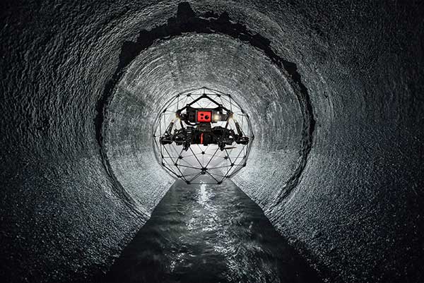
Over the past decade, drone technology has continually impacted sewer inspections – allowing inspectors to improve safety, save money, and reduce response time in the face of emergencies. As physically entering pipes with flashlight in hand creates dangerous and “snapshot” reporting of issues drone footage can provide reviewable and safer examinations. Today, with the use of drones in inspections, municipalities are able to more effectively perform full assessments of sewer systems and be more proactive with the need for potential repairs.
Drone technology is not a new concept to the water and wastewater industry. For years, crawling drones have delivered live video feeds from underground, with some of them even outfitted to cut pipes, weld seams, and more. Swimming drones have even been known to explore activity below the waterline. Most notably, the rapid increase of video-capable aerial drones and data-analysis programs has also transformed how engineers generate surveys and 3D maps.1 In addition, with use of drone services, municipalities and engineers are able to access outfall, culvert, and difficult to reach easement areas that were difficult to assess.
The use of drones has even shifted into robotic inspections of sewer pipelines and material testing of extracted core samples of the pipelines to predict their service life. Utilizing artificial intelligence, the growing trend is to be able to provide municipalities valuable information to inform future decisions about infrastructure.
As system operators and engineers come to trust these tools, new advancements are continuing to make drones and artificial intelligence easier to use, while the technology’s data collection options continue to grow more dynamic. All of this combines to make drone platforms an overall safer and more efficient inspection solution.
T4 Vault stays ahead of this ever-changing technology, adapting our cloud-based interface to keep all data received from these inspections safe and instantly available. T4 Vault allows municipalities to upload all of the data to a secure, cloud-based platform to catalog, store, link to GIS, and share with ease. Moving inspection data onto the system is as simple as a fast drag and drop of a file.
Phone: +1 805-921-3000
Support: support@t4spatial.com
Sales: mthompson@t4spatial.com
1 Duffy, L. (2020, June 17) Drones Can Safely Perform Inspections in Dangerous Conditions from GeoData Point. Retrieved from: https://www.pobonline.com/articles/102180-drones-can-safely-perform-inspections-in-dangerous-conditions